
New Philadelphia, Ohio - As part of the flood risk management operation of the reservoirs and dams in the Muskingum River Watershed, the U.S. Army Corps of Engineers (USACE) conducts annual temporary drawdown of the normal pool elevation of the lake levels. The drawdown allows for additional flood storage capacity needed during the winter thaw and spring rains. Drawdown will begin in early November and the return to normal pool elevation will initiate in February. Normal pool elevations will be obtained in time for the summer recreation season.
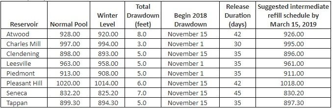
The temporary 2018-2019 drawdown dates and lake levels are as follows:
The drawdown provides flood storage capacity for the spring rains while also providing the opportunity to complete maintenance improvements in and around the reservoirs. As a continuation of this program, one project within Atwood Lake Park is scheduled during this year’s winter drawdown at an estimated cost of $1,529,000.
This project is being funded by a Clean Ohio grant, which will cover up to 75 percent of the total project costs, including design and other non-construction costs. The project is approximately 1,400 feet in length and is needed to protect the failing slope along the peninsula roadway between the Area D and Area F campgrounds.
MWCD manages over 300 miles of shoreline throughout the 10 MWCD lakes located in central and eastern Ohio. Over 8.2 miles of MWCD shoreline has been stabilized at a cost of $8.8 million since 2009. Funding for shoreline projects is from several sources including the MWCD maintenance assessment, grants from Clean Ohio and revenue from oil and gas. The 10 MWCD owned lakes include Atwood, Leesville, Tappan, Clendening, Piedmont, Seneca, Charles Mill, Pleasant Hill, Wills Creek and Beach City.
About the Muskingum Watershed Conservancy District
The MWCD, a political subdivision of the state, was organized in 1933 to develop and implement a plan to reduce flooding and conserve water for beneficial public uses in the Muskingum River Watershed, the largest wholly contained watershed in the State of Ohio. The District includes 18 counties and covers 8,000 square miles, or approximately 20 percent of the state. The District’s 16 reservoirs and dams have been credited for saving an estimated $11.9 billion of potential property damage from flooding, per the federal government. In addition, over 5.5 million customers a year use the District’s recreational facilities throughout Eastern Ohio which bolsters the region’s economy and augments the quality of life for Ohio’s residents.
The mission of Muskingum Watershed Conservancy District is, “Responsible stewards dedicated to providing the benefits of flood reduction, conservation and recreation in the Muskingum River Watershed.”
For more information about the MWCD visit www.mwcd.org.
MUSKINGUM WATERSHED CONSERVANCY DISTRICT